ภาพประกอบสร้างโดยเทคโนโลยี AI (Visual enhanced by AI technology)
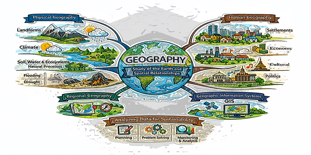
Geography: ภูมิศาสตร์ (Geography) เป็นศาสตร์ที่ศึกษาและอธิบายในเรื่องของโลก มุ่งเน้นการอธิบายความแตกต่างและความสัมพันธ์ของปรากฏการณ์บนพื้นผิวโลก โดยการวิเคราะห์เชิงพื้นที่ (spatial analysis) และการทำความเข้าใจรูปแบบ (patterns) และกระบวนการ (processes) ของความสัมพันธ์ระหว่างมนุษย์กับสิ่งแวดล้อมในมิติของพื้นที่ โดยครอบคลุมทั้งลักษณะทางกายภาพและกิจกรรมของมนุษย์
การศึกษาที่เกี่ยวกับองค์ประกอบทางธรรมชาติ เช่น ภูมิประเทศ (landforms) ภูมิอากาศ (climate) ดิน น้ำ และระบบนิเวศ (ecosystems) การทำความเข้าใจกระบวนการทางธรรมชาติ เช่น การกัดเซาะ การเปลี่ยนแปลงของภูมิอากาศ การเกิดน้ำท่วม การเกิดภัยแล้ง ฯลฯ เนื้อหาเหล่านี้เราเรียกว่า ภูมิศาสตร์กายภาพ (Physical Geography) ในขณะที่การศึกษาปรัชญา แนวคิดและกิจกรรมของมนุษย์ ตลอดจนความสัมพันธ์ที่เกิดขึ้นกับพื้นที่ เช่น การตั้งถิ่นฐาน เศรษฐกิจ วัฒนธรรม และการเมือง เราเรียกการศึกษาเนื้อหาเหล่านี้ว่า ภูมิศาสตร์มนุษย์ (Human Geography)
นักภูมิศาสตร์ใช้เทคนิคและเครื่องมือทางภูมิศาสตร์ศึกษาและอธิบายในเรื่องของโลก จึงทำให้เกิดเนื้อหาและสาขาวิชาอื่น ๆ กระจายออกไป เช่น การใช้เทคนิคการแบ่งพื้นที่ตามลักษณะร่วมที่นักภูมิศาสตร์เรียกว่า ภูมิศาสตร์ภูมิภาค (Regional Geography) ก็ถูกนำมาใช้เป็นหลักในการศึกษาด้านการวางแผนและการวางผังเมือง การใช้เทคนิคด้านการปฏิสัมพันธ์เชิงพื้นที่การถูกนำมาออกแบบเป็นเครื่องมือหรือคำสั่งของการทำงานในระบบสารสนเทศภูมิศาสตร์ (GIS) เป็นต้น
ดังนั้น การนำเสนอข้อมูลและสารสนเทศของ GEO2GIS จึงมุ่งเน้นการนำข้อมูล ข้อเท็จจริงมาวิเคราะห์การเกิดปรากฏการณ์ การแก้ไขปัญหาที่เกิดเพื่อช่วยให้เราเข้าใจโลกในมิติของพื้นที่และเวลา ด้วยแนวคิดพื้นฐานและเทคโนโลยีทางภูมิศาสตร์ที่มีบทบาทในโลกยุคใหม่ ซึ่ง GEO2GIS เชื่อว่าการส่งเสริมการคิดเชิงพื้นที่เป็นสิ่งจำเป็นสำหรับการพัฒนาอย่างยั่งยืนในอนาคตต่อไป
Geography is a discipline dedicated to studying and explaining the Earth, focusing primarily on understanding spatial variations and relationships among phenomena occurring on its surface. It emphasizes spatial analysis and aims to interpret the patterns and processes that shape the interactions between humans and the environment across space and time. This field encompasses both the physical characteristics of the Earth and human activities. The study of natural components—such as landforms, climate, soil, water, and ecosystems—and natural processes—such as erosion, climate change, flooding, and drought—is known as Physical Geography. In contrast, Human Geography focuses on human philosophies, concepts, activities, and their spatial relationships, including settlement patterns, economic systems, cultural practices, and political structures. Geographers utilize a variety of techniques and tools to analyze and explain the Earth, leading to the emergence of numerous subfields. For instance, the technique of classifying areas based on shared characteristics, referred to as Regional Geography, plays a fundamental role in urban and regional planning. Additionally, concepts of spatial interaction have been developed into operational tools and functions within Geographic Information Systems (GIS). Consequently, GEO2GIS focuses on analyzing spatial phenomena and addressing real-world problems through evidence-based insights. This approach aims to enhance our understanding of the world in both spatial and temporal dimensions by employing fundamental geographic concepts and modern geospatial technologies. GEO2GIS firmly believes that fostering spatial thinking is essential for achieving sustainable development in the future.