ภาพประกอบสร้างโดยเทคโนโลยี AI (Visual enhanced by AI technology)
ระบบสารสนเทศภูมิศาสตร์ (Geographic Information System: GIS) เป็นเครื่องมือสำคัญในการจัดการ วิเคราะห์ และแสดงผลข้อมูลเชิงพื้นที่ โดยผสานข้อมูลเชิงตำแหน่งกับข้อมูลเชิงคุณลักษณะเข้าด้วยกัน
GIS ถูกนำไปใช้ในหลากหลายสาขา เช่น การวางผังเมือง การจัดการทรัพยากรธรรมชาติ และการบริหารจัดการภัยพิบัติ GIS มีองค์ประกอบสำคัญ 2 ประเภท ได้แก่ ข้อมูลเชิงพื้นที่ (Spatial Data): ข้อมูลที่ระบุพิกัดตำแหน่ง เช่น จุด เส้น และพื้นที่ ข้อมูลเชิงคุณลักษณะ (Attribute Data): ข้อมูลรายละเอียดของสิ่งนั้น เช่น ชื่อ ประเภท หรือคุณสมบัติ
GIS ประกอบด้วย 5 องค์ประกอบที่ต้องทำงานร่วมกันอย่างเป็นระบบ โดยองค์ประกอบ 5 ส่วน คือ
1. ฮาร์ดแวร์ (Hardware): คอมพิวเตอร์และอุปกรณ์ที่ใช้ประมวลผล
2. ซอฟต์แวร์ (Software): โปรแกรมสำหรับจัดการและวิเคราะห์ข้อมูล เช่น ArcGIS หรือ QGIS
3. ข้อมูล (Data): ทั้งข้อมูลเชิงพื้นที่และข้อมูลเชิงคุณลักษณะ
4. บุคลากร (People): ผู้ใช้งานและผู้เชี่ยวชาญด้าน GIS
5. กระบวนการ (Methods): ขั้นตอนและวิธีการวิเคราะห์ข้อมูล
กระบวนการทำงานของ GIS ประกอบด้วย
- การเก็บรวบรวมข้อมูล (Data Collection): แหล่งข้อมูลมีทั้งการสำรวจในพื้นที่ การรวบรวมข้อมูลจากแหล่งข้อมูลต่าง ๆ การนำเข้าข้อมูลจากเทคโนโลยีที่เกี่ยวข้อง เช่น ข้อมูลจาก ภาพถ่ายจากดาวเทียม ระบบ GPS ภาพถ่ายทางอากาศ ฯลฯ
- การจัดเก็บและจัดการข้อมูล (Data Management): เป็นการออกแบบและการจัดระบบฐานข้อมูล
- การวิเคราะห์ข้อมูล (Spatial Analysis): เป็นการนำข้อมูลมาใช้งานด้วยการดูภาพ การค้นหาข้อมูล การตรวจวัดข้อมูลเชิงพื้นที่ เช่น การวัดระยะ วัดพื้นที่ วัดความสูง วัดความลาดชัน ฯลฯ การวิเคราะห์ด้วยการผสมผสานข้อมูล เช่น การใช้ overlay Technique การทำ Buffering การทำ Generalization เป็นต้น
- การแสดงผล (Visualization): การนำเสนอข้อมูลในรูปแบบแผนที่หรือกราฟ ตารางข้อมูล การทำ Application การแสดงผลในรูป Dashboard เป็นต้น
การวิเคราะห์เชิงพื้นที่เป็นหัวใจสำคัญของ GIS ดังนั้นจึงมีการนำ GIS ไปประยุกต์ใช้งานหลายด้าน เช่น การวางผังเมือง (Urban Planning) การจัดการทรัพยากรธรรมชาติ (Natural Resource Management) การจัดการภัยพิบัติ (Disaster Management) การวิเคราะห์เส้นทางและการจราจร เป็นต้น
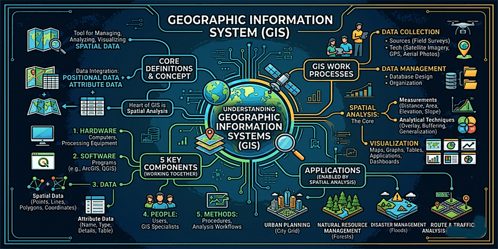
Geographic Information Systems (GIS)
A Geographic Information System (GIS) is a powerful tool for managing, analyzing, and visualizing spatial data by integrating location-based information with descriptive (attribute) data.
GIS is widely applied across various fields, including urban planning, natural resource management, and disaster management. It operates through two fundamental types of data: spatial data, which represent geographic locations in the form of points, lines, and polygons, and attribute data, which provide descriptive information about those spatial features, such as names, categories, and properties.
A GIS functions through five essential components that work systematically together:
- Hardware: Computers and devices used for data processing
- Software: Programs for managing and analyzing spatial data, such as ArcGIS and QGIS
- Data: Both spatial and attribute data
- People: Users and GIS specialists
- Methods: Procedures and techniques for data analysis
The workflow of GIS consists of several key processes:
- Data Collection: Gathering data from various sources, including field surveys, existing datasets, and geospatial technologies such as satellite imagery, GPS, and aerial photography.
- Data Management: Organizing and designing databases for efficient storage and retrieval.
- Spatial Analysis: Examining spatial relationships through visualization, querying, and measurement (e.g., distance, area, elevation, and slope). Advanced techniques include overlay analysis, buffering, and generalization.
- Visualization: Presenting data in the form of maps, charts, tables, applications, and dashboards.
Spatial analysis lies at the core of GIS, enabling its application in a wide range of domains, such as urban planning, natural resource management, disaster management, and transportation and route analysis.