 ภาพประกอบสร้างโดยเทคโนโลยี AI (Visual enhanced by AI technology)
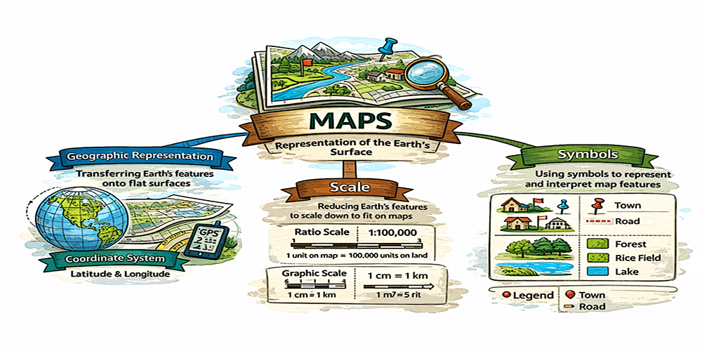
แผนที่ หมายถึงสิ่งที่แสดงลักษณะของพื้นผิวโลกทั้งหมด หรือบางส่วนบนพื้นราบโดยการย่อส่วนและใช้สัญลักษณ์แทนรายละเอียดต่าง ๆ ที่ปรากฏอยู่ สิ่งที่สำคัญในความหมายของแผนที่ ประกอบด้วย การถ่ายทอดลักษณะของพื้นผิวโลกลงสู่พื้นราบ การย่อส่วน และสัญลักษณ์
การถ่ายทอดลักษณะของพื้นผิวโลกลงสู่พื้นราบต้องมีความรู้ ความเข้าใจเรื่องระบบพิกัด ซึ่งระบบพิกัดเป็นระบบการอ่านค่าตัวเลขในเชิงตำแหน่งบนพื้นที่ ซึ่งจะสามารถนำไปอ้างอิงคำนวณระยะทาง พื้นที่ ปริมาตรได้
การย่อส่วน เป็นการย่อสิ่งที่ปรากฏบนพื้นโลกจริงๆ ลงมาในแผนที่ซึ่งเราเรียกว่า สัดส่วนหรือมาตราส่วน ดังนั้น มาตราส่วนจึงหมายถึง อัตราส่วนเปรียบเทียบระหว่างระยะทางในแผนที่กับระยะทางในภูมิประเทศจริง โดยกำหนดให้ระยะทางในแผนที่เป็น 1 หน่วย
สัญลักษณ์แผนที่จะปรากฏเป็น 3 ลักษณะ คือ สัญลักษณ์ที่มีลักษณะเป็น จุด (point) เช่น ที่ตั้งจังหวัด อำเภอ วัดมีโบสถ์ วัดไม่มีโบสถ์ โรงเรียน สัญลักษณ์ที่มีลักษณะเป็น เส้น (line) เช่น แนวแบ่งเขตจังหวัด ถนน ทางน้ำ และเส้นชั้นความสูง และสัญลักษณ์ที่มีลักษณะเป็นพื้นที่ (polygon) เช่น สวนหรือไร่ สวนป่า ทุ่งนา แหล่งน้ำ ในสัญลักษณ์ต่างๆ อาจจะมีข้อความเพื่ออธิบาย และการแสดงสี โดยทั่วไปสัญลักษณ์จะออกแบบให้สื่อสารกับผู้ใช้งานได้ใกล้เคียงกับ ลักษณะภูมิประเทศจริงมากที่สุด เพื่อความสะดวกต่อการแปลความ เช่น ทุ่งนา มีสัญลักษณ์คล้ายกับต้นข้าวทั่วทั้งพื้นที่ที่เป็นทุ่งนา แหล่งน้ำกำหนดให้เป็นบริเวณที่มีสีน้ำเงินซึ่งเป็นสีที่มีลักษณะใกล้เคียงกับสีน้ำทะเล ทางรถไฟจะมีลักษณะคล้ายรางรถไฟ โรงเรียน มีลักษณะคล้ายเสาธงชาติ เป็นต้น
A map is defined as a representation of the Earth’s surface, either in its entirety or in part, depicted on a flat plane through the processes of scale reduction and the use of symbols to represent various features. The essential elements of a map, therefore, include the projection of the Earth’s surface onto a plane, scale reduction, and symbolic representation.
The transformation of the Earth’s surface onto a flat plane requires knowledge and understanding of coordinate systems. A coordinate system is a framework for expressing numerical values that indicate positions in space, which can be used as a reference for calculating distances, areas, and volumes.
Scale reduction refers to the process of reducing real-world features onto a map, commonly expressed as a ratio or scale. Thus, scale is defined as the proportional relationship between a distance on the map and the corresponding distance on the actual terrain, with the map distance conventionally represented as one unit.
Map symbols can be classified into three main types. There are three main types of symbols used in mapping:
1. Point symbols: These represent specific locations, such as provincial centers, districts, temples (with or without chapels), and schools.
2. Line symbols: These indicate linear features, including administrative boundaries, roads, waterways, and contour lines.
3. Polygon symbols: These represent areas, such as orchards, plantations, forests, rice fields, and bodies of water.
In addition to symbols, maps may include textual annotations and the use of color to enhance interpretation. Generally, symbols are designed to communicate information to users in a manner that closely resembles real-world features, thereby facilitating ease of interpretation. For example, rice fields may be represented by symbols resembling rice plants distributed across the area; water bodies are typically shown in blue to reflect the natural color of water; railways are depicted in a form similar to tracks; and schools may be represented by symbols resembling flagpoles.