ภาพประกอบสร้างโดยเทคโนโลยี AI (Visual enhanced by AI technology)
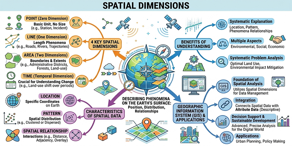
มิติเชิงพื้นที่ (Spatial Dimensions) เป็นแนวคิดสำคัญของนักภูมิศาสตร์ที่ใช้ในการอธิบายตำแหน่ง การกระจาย และความสัมพันธ์ของปรากฏการณ์บนพื้นผิวโลก โดยครอบคลุมมิติหลัก ได้แก่ จุด (point) เส้น (line) พื้นที่ (area) และเวลา (time) การทำความเข้าใจมิติเชิงพื้นที่ช่วยให้สามารถอธิบายตำแหน่ง รูปแบบ และความสัมพันธ์ของปรากฏการณ์ต่าง ๆ ได้อย่างเป็นระบบ ทั้งในด้านสิ่งแวดล้อม สังคม และเศรษฐกิจ
โดย จุด (Point Dimension) เป็นหน่วยพื้นฐานที่ใช้แทนตำแหน่งที่ไม่มีขนาด เช่น ที่ตั้งของสถานีตรวจวัด หรือจุดเกิดเหตุ เส้น (Line Dimension) ใช้แทนปรากฏการณ์ที่มีความยาว เช่น ถนน แม่น้ำ หรือเส้นทางการเคลื่อนที่ พื้นที่ (Area Dimension) ใช้แทนขอบเขตของสิ่งต่าง ๆ เช่น เขตการปกครอง พื้นที่ป่าไม้ หรือพื้นที่การใช้ที่ดิน และมิติเวลา (Temporal Dimension) เป็นองค์ประกอบสำคัญที่ช่วยให้เข้าใจการเปลี่ยนแปลงของข้อมูล เช่น การเปลี่ยนแปลงการใช้ที่ดินในช่วงเวลา
ลักษณะของข้อมูลเชิงพื้นที่ (Characteristics of Spatial Data) มีความแตกต่างจากข้อมูลทั่วไป ได้แก่
- ตำแหน่ง (Location): ระบุพิกัดบนพื้นโลก
- รูปแบบ (Pattern): การกระจายตัว เช่น กระจุกตัวหรือกระจาย
- ความสัมพันธ์ (Spatial Relationship): เช่น ระยะทาง การติดกัน (adjacency) หรือการซ้อนทับ (overlay)
การเข้าใจลักษณะเหล่านี้เป็นพื้นฐานของการวิเคราะห์เชิงพื้นที่ โดยเฉพาะระบบสารสนเทศภูมิศาสตร์ (GIS) ที่ใช้มิติเชิงพื้นที่เป็นพื้นฐานในการจัดการข้อมูล พร้อมทั้งเชื่อมโยงกับข้อมูลเชิงคุณลักษณะ การใช้ GIS ช่วยให้สามารถวิเคราะห์ข้อมูลเชิงพื้นที่ได้อย่างซับซ้อนและแม่นยำ สามารถวิเคราะห์ปัญหาในเชิงพื้นที่ได้อย่างเป็นระบบ เช่น การใช้ที่ดินอย่างเหมาะสม การลดผลกระทบต่อสิ่งแวดล้อม และการวางแผนพัฒนาเมือง ในโลกยุคดิจิทัล มิติเชิงพื้นที่จึงมีบทบาทสำคัญในการสนับสนุนการตัดสินใจและการพัฒนาพื้นที่อย่างยั่งยืน
Spatial dimensions are a fundamental concept in geography used to explain the location, distribution, and relationships of phenomena on the Earth’s surface. These dimensions primarily include point, line, area, and time. Understanding spatial dimensions enables a systematic interpretation of the location, patterns, and relationships of various phenomena across environmental, social, and economic contexts.
The point dimension represents the most basic spatial unit, indicating a location without physical size, such as monitoring stations or incident locations. The line dimension represents phenomena with length, such as roads, rivers, or movement paths. The area dimension represents the extent or boundary of features, such as administrative regions, forest areas, or land-use zones. The temporal dimension (time) is a critical component that allows for the analysis of change over time, such as land-use changes across different periods.
Spatial data possess distinct characteristics that differentiate them from general data, including:
- Location: Identifies geographic coordinates on the Earth’s surface
- Pattern: Describes spatial distribution, such as clustering or dispersion
- Spatial Relationships: Includes distance, adjacency, and overlay
Understanding these characteristics forms the foundation of spatial analysis, particularly in Geographic Information Systems (GIS), where spatial dimensions are essential for data management and integration with attribute data. GIS enables complex and accurate spatial analysis, supporting systematic problem-solving in areas such as land-use planning, environmental impact reduction, and urban development.
In the digital era, spatial dimensions play a crucial role in supporting decision-making and promoting sustainable spatial development.