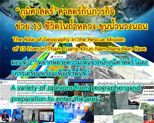


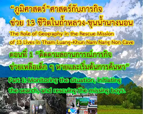
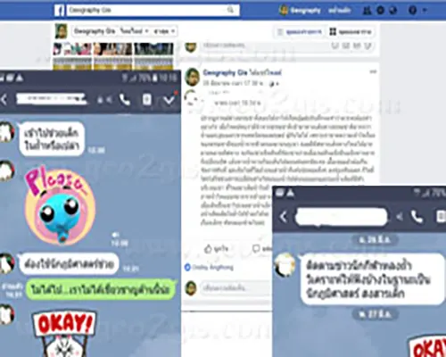
“ติดตามสถานการณ์ภารกิจช่วยเหลือเด็ก ๆ หายและเริ่มต้นการค้นหา” Monitoring the situation, initiating the search, and rescuing the missing boys.
ในอดีตการเรียนรู้และศึกษาของนักภูมิศาสตร์ส่วนหนึ่งเกิดจากการสำรวจ การสังเกต การสอบถามและบันทึกเรื่องราวต่าง ๆ ในพื้นที่ ทั้งที่เกี่ยวกับภูมิประเทศ ภูมิอากาศ สิ่งมีชีวิตตลอดจนความสัมพันธ์เกี่ยวข้องระหว่างมนุษย์กับสิ่งแวดล้อม ซึ่งข้อมูลเหล่านี้กลายเป็นองค์ความรู้ทางภูมิศาสตร์ที่แพร่กระจายและขยายสาขาออกไปมากมาย แม้ในระยะหลังมนุษย์จะเชื่อถือและให้ความสำคัญกับความรู้ที่อ้างอิงจากข้อมูลตัวเลขก็ตาม ความรู้ที่เป็นเรื่องเล่าและเรื่องราวก็จะยังเป็นสิ่งที่มนุษย์สามารถนำมาใช้ประโยชน์ในชีวิตได้ และต่อไปนี้จะเป็นเรื่องเล่าที่เกิดจากการบันทึกข้อมูลที่ขึ้นในพื้นหนึ่ง ในเวลาหนึ่ง และในความทรงจำหนึ่ง
Geographers in the past used to learn and explore by surveying, observing, questioning, and recording the stories of the area. This included aspects related to topography, climate, living organisms, as well as the complex relationships between humans and the environment. With time, this information has evolved into a diverse body of geographical knowledge, branching out into various fields. Although humans have come to place importance on knowledge derived from numerical data, the storytelling aspect of knowledge, and the narratives that have been passed down, remain valuable. People continue to benefit from the stories that emerge from records documented in a particular place at a specific time, forming lasting memories.
ภายหลังการเกิดเหตุการณ์ “13 ชีวิตติดในถ้ำหลวง-ขุนน้ำนางนอน” ผมในฐานะนักภูมิศาสตร์และ Web Master: www.geo2gis.com ที่เพื่อนๆ รู้จักและติดตามผลงานถูกเพื่อนๆ สอบถามถึงแนวคิด วิธีการของนักภูมิศาสตร์ต่อการช่วยเหลือน้อง ๆ 13 ชีวิตที่ติดอยู่ในถ้ำหลวง-ขุนน้ำนางนอน เนื่องจากเพื่อน ๆ รู้ว่า “นักภูมิศาสตร์” เป็นส่วนหนึ่งที่เข้ามามีบทบาทในเหตุการณ์ดังกล่าว ทั้งด้านการเข้าไปช่วยเหลือในพื้นที่ การให้ข้อมูลและการวิเคราะห์ข้อมูลผ่านสื่อต่าง ๆ
As a geographer and Web Master of www.geo2gis.com, I would like to bring attention to the important work done by geographers following the incident of '13 Lives Trapped in Tham Luang-Khun Nam Nang Non Cave.' If you are curious about the concepts and methodologies employed by geographers to aid the 13 lives stranded in the cave, please feel free to inquire. It is important to note that geographers played a crucial role in this event, both in terms of on-site assistance and the provision and analysis of information through various media channels.
เพื่อนๆ ติดต่อผ่านสื่อ Social สอบถามถึงแนวคิดนักภูมิศาสตร์ต่อสถานการณ์ฯ เนื่องจาก “นักภูมิศาสตร์” เป็นส่วนหนึ่งที่เข้ามามีบทบาทในเหตุการณ์ดังกล่าว Friends reached out on social media to ask for a geographical perspective on the current situation, as geographers play a role in the unfolding events.
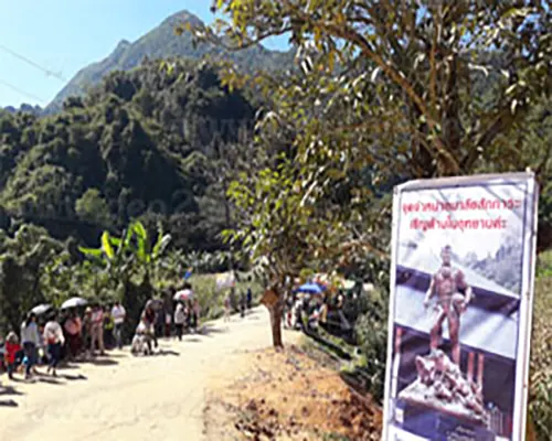
สำหรับผมตั้งใจไว้ตั้งแต่เกิดเหตุการณ์ว่าผมจะต้องเข้าไปในพื้นที่ที่เกิดเหตุเพื่อสังเกตพื้นที่จริงแบบนักภูมิศาสตร์ แล้วบันทึกเหตุการณ์ในส่วนที่องค์ความรู้ทางภูมิศาสตร์เข้าไปมีส่วนเกี่ยวข้อง แล้ววันที่ 23 ธันวาคม 2561 ผมก็ได้เดินทางโดยการขับรถยนต์ส่วนตัวไปที่วนอุทยานถ้ำหลวง–ขุนน้ำนางนอน ได้สัมผัสและรับรู้ถึงพื้นที่จริงแม้ว่าปัจจุบันจะมีการเปลี่ยนแปลงไป แต่สำหรับการจินตนาการบรรยากาศการปฏิบัติภารกิจในพื้นที่ของผู้ที่เข้าไปมีส่วนร่วมในเหตุการณ์ ในเวลานั้นแล้ว ยังคงสามารถสังเกตเห็นร่องลอยเหตุการณ์ความยุ่งยากลำบากในพื้นที่อย่างชัดเจน
From the moment the incident occurred, I was determined to visit the affected area myself as a geographer. Finally, on December 23, 2018, I set off on my journey, driving my own car to Tham Luang-Khun Nam Nang Non Forest Park. I explored the actual terrain and even though it has undergone some changes since the incident, one could still vividly witness the traces and intricacies of the challenges in the area. It was an imaginative atmosphere, and one could still feel the intense mission execution of those involved in the events at that time.
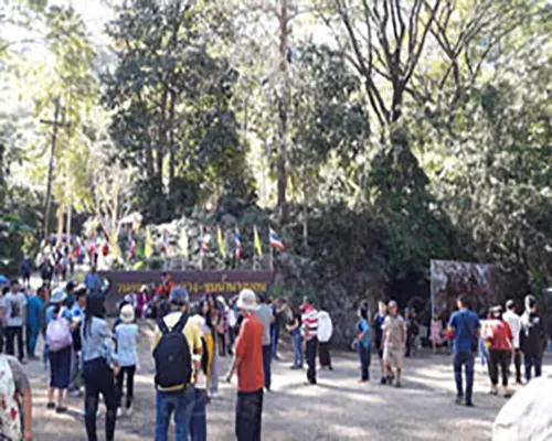
ทางเดินเข้าสู่ถ้ำหลวง เส้นทางปัจจุบันที่นักท่องเที่ยวและผู้สนใจในเหตุการณ์จำนวนมากมายใช้เดินทางเข้าไปสู่พื้นที่เกิดเหตุ บ้างเข้าไปท่องเที่ยว บางคนที่สนใจเหตุการณ์ก็ต้องการเข้าไปสังเกต เข้าไปรับรู้บรรยากาศที่เคยเกิดขึ้นในวันนั้น The route leading to the Tham Luang cave, which is now commonly used by tourists and those interested in the event, serves as the entrance to the area where the incident occurred. Some visitors come to the site for tourism purposes, while others are intrigued by the historical event and want to experience the atmosphere of that day.
ป้ายบอกสถานที่วนอุทยานฯ ยังคงเป็นจุดที่หลายคนสนใจเข้าไปถ่ายรูปเพื่อเก็บไว้ยืนยันว่าได้เดินทางมาที่นี่แล้ว The Forest Park entrance sign attracts visitors who take photos to commemorate their visit.
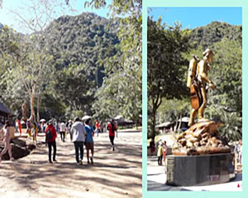
อนุสาวรีย์จ่าแช่ม วีรบุรุษที่เสียชีวิตในเหตุการณ์ ถ้ำหลวงฯ ถูกสร้างขึ้นเพื่อเตือนใจให้หลายคนจดจำเหตุการณ์และความดีที่ร่วมสร้างไว้กับจ่าแช่ม The Ja Sam Memorial serves as a poignant reminder of the heroes who lost their lives in the Tham Luang cave incident and the compassion that Ja Sam embodied.
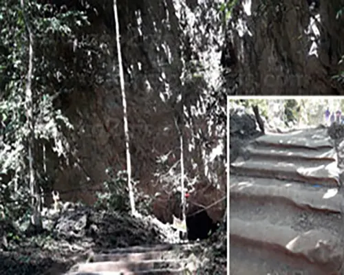
กระสอบปูบนทางเดินเพื่อป้องกันการลื่นล้มเป็นร่องรอยที่ปรากฏในพื้นที่ซึ่งยังคงพบเห็นอยู่ตลอดเส้นทางเข้าสู่ปากถ้ำและเส้นทางโดยรอบ Sacks filled with sand are placed on the path to prevent slipping near the cave entrance and surrounding areas.
เหตุการณ์ “13 ชีวิตติดในถ้ำหลวง-ขุนน้ำนางนอน”ถูกติดตามอย่างต่อเนื่องโดย วิทยุ โทรทัศน์ สื่อสิ่งพิมพ์ต่าง ๆ แทบทุกสำนักทั้งในประเทศและต่างประเทศ รวมไปถึงสื่อที่เป็น Social media ก็มีการติดตามและแสดงความคิดเห็นวันต่อวัน นาทีต่อนาที สำหรับผมแล้ว การเฝ้าติดตามเหตุการณ์ผ่านสื่อ หลายสื่อ หลายสำนักโดยเฉพาะผ่านการรายงานของสถานีโทรทัศน์ที่ติดตามสถานการณ์อย่างใกล้ชิดจนได้เห็นและเข้าถึงเหตุการณ์หลายด้าน หลายมุม หลายพื้นที่ในเวลาเดียวกัน ทำให้การทบทวน การหาข้อมูลเพื่อนำมาเขียนเล่าเหตุการณ์สามารถปะติดปะต่อได้อย่างชัดเจนพอสมควร
The incident where 13 people were trapped in the Tham Luang-Khun Nam Nang Non Cave was closely monitored by various media outlets, both nationally and internationally. Social media in particular followed and expressed opinions on the situation minute by minute. Personally, I kept a close eye on the event through different media, especially the reports of television stations that closely followed the situation. This allowed me to see and access various aspects, angles and areas simultaneously, which facilitated a thorough review and data gathering, providing a clear and well-rounded narrative of the events as deemed appropriate.
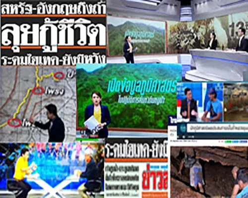
สื่อวิทยุ โทรทัศน์ สื่อสิ่งพิมพ์ต่าง ๆ แทบทุกสำนักทั้งในประเทศและต่างประเทศ รวมถึงสื่อที่เป็น Social media ต่างติดตามและแสดงความคิดเห็นต่อเหตุการณ์วันต่อวัน นาทีต่อนาที Radio, television and print media, both national and international, covered the event extensively, including social media, with constant opinions expressed day by day and minute by minute.
การพยายามทบทวนและเขียนเล่าเหตุการณ์ เขียนบ้างหยุดบ้างจนกระทั้งครบรอบ 1 ปีที่เกิดเหตุการณ์ฯ จึงมีโอกาสนำเอาข้อเขียนภายใต้แนวคิด วิธีการของนักภูมิศาสตร์มาเผยแพร่ ทั้งนี้เนื้อหาที่เขียนจะอ้างอิงข้อเท็จจริงจากเหตุการณ์ที่เกิดขึ้นตามลำดับเป็นรายวัน พร้อมกับการนำเสนอความรู้และข้อคิดเห็นทางภูมิศาสตร์ประกอบไปด้วย
I wrote intermittently in an attempt to review and narrate the events until the one-year anniversary of the incident. This time frame allowed me to share my writings using a geographical perspective and methodology. My writing will include factual details of the daily events that occurred, along with presenting geographical knowledge and insights.
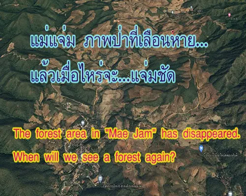
“ดอยนางนอน” และ “ถ้ำหลวง-ขุนน้ำนางนอน”
“Doi Nang Non” and "Tham Luang-Khun Nam Nang Non"
เทือกเขาแดนลาวที่ทอดตัวเป็นแนวยาวจากเหนือจดใต้ เป็นแนวพรหมแดนกั่นระหว่างรัฐฉาน สหภาพเมียนม่าร์กับจังหวัดเชียงราย ราชอาณาจักรไทย ทางด้านเหนือตอนบนของเทือกเขาถูกเรียกว่า ดอยนางนอน หากมองไปตามแนวภูเขาที่ทอดยาวทางฝั่งตะวันตกของถนนพหลโยธินจากเชียงรายไปยังอำเภอแม่สายจะเห็นคล้ายกับรูปผู้หญิงทอดกายนอนหงายปลายเท้าอยู่ในเขตอำเภอแม่จัน ส่วนหัวอยู่ในเขตของอำเภอแม่สาย โดยส่วนหัวสุดอยู่บริเวณบ้านผาหมี ตำบลเวียงพางคำ ส่วนจมูกและใบหน้าอยู่บริเวณบ้านจ้อง ตำบลโป่งผาซึ่งเป็นที่ตั้งของ “วนอุทยานถ้ำหลวง–ขุนน้ำนางนอน” แหล่งท่องเที่ยวทางธรรมชาติที่น่าสนใจ
The "Dan Laos" mountain range serves as a natural boundary between Shan State, Myanmar, and Chiang Rai Province, Thailand. Doi Nang Non is the name given to the northern section of the mountain range. If you look at it from the western side of Phaholyothin Road, which runs from Chiang Rai to Mae Sai District, you can see the shape of a reclining woman, with her feet stretching into Mae Chan District and her head in Mae Sai District. Baan Pha Mee in Wiang Pang Kham Subdistrict is where you'll find the northernmost part. The nose and face are in the area around Ban Jong in Pong Pha Suea Subdistrict, which is the location of the 'Tham Luang-Khun Nam Nang Non' Cave Complex, a fascinating natural tourist attraction.
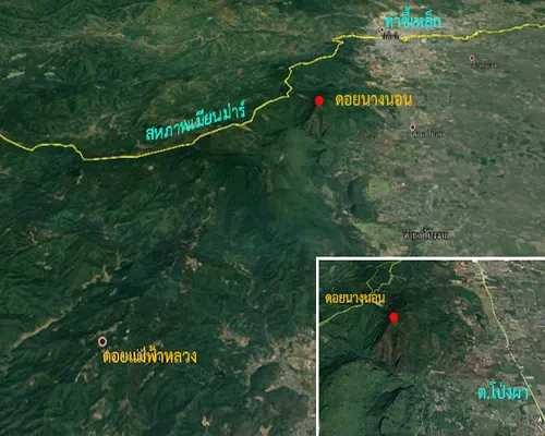
เทือกเขาแดนลาวทอดตัวเป็นแนวยาวจากเหนือจดใต้ เป็นแนวพรหมแดนกั่นสหภาพเมียนม่าร์กับประเทศไทย ตอนเหนือของเทือกเขาแดนลาวเป็นที่ตั้ง ดอยนางนอ และดอยตุง (ที่มาของภาพถ่าย : จากดาวเทียม Google Earth)
Serving as a natural boundary, the "Dan Laos" mountain range separates Shan State, Myanmar, from Chiang Rai Province, Thailand. Doi Nang Non and Doi Tung are located in the northern part of the "Dan Laos" mountain range.
ดอยนางนอนเป็นที่ตั้งของพระธาตุดอยตุง โดยเทือกเขามีจุดสูงสุดคือ ผาช้างมูบ มีความสูงจากระดับน้ำทะเลประมาณ 830 เมตร พื้นที่ทางตะวันตกเป็นที่สูงและลาดลงไปทางตะวันออก (ทำให้ด้านตะวันออกของดอยนางนอนเป็นพื้นที่ทำการเกษตร ไปจนจรดเขตอำเภอเชียงแสน) ทางทิศใต้เป็นที่ราบติดกับอำเภอแม่จันและอำเภอแม่ฟ้าหลวง สภาพพื้นที่ทั่วไปของดอยนางนอนเป็นภูเขาหินปูนมีถ้ำอยู่หลายแห่ง ถ้ำหลวงเป็นถ้ำที่อยู่ในพื้นที่วนอุทยานถ้ำหลวง–ขุนน้ำนางนอน ซึ่งนักฟุตบอลเด็กทีมหมูป่าอะคาเดมีเข้าไปเที่ยวและติดอยู่ข้างใน
The highest point of the mountain range in Doi Nang Non is the 'Pha Chang Mub' cliff, reaching an elevation of around 830 meters above sea level. The western side of the mountain range is elevated and slopes down towards the east (leading to the eastern side of Doi Nang Non being utilized for agriculture, extending into the Chiang Saen District). The southern side is a plain, bordering Mae Chan District and Mae Fa Luang District. Limestone mountains characterized the general terrain of Doi Nang Non with many caves. Tham Luang is a cave located within the Tham Luang–Khun Nam Nang Non Forest Park area. When a youth soccer team went into a cave for recreational purposes and couldn't find a way out, they gained prominence.
ดอยนางนอนทอดยาวทางฝั่งตะวันตกของถนนพหลโยธิน หากขับรถไปทางเหนือตามเส้นทางเมื่อมองไปทางทิศตะวันตกจะเห็นดอยนางนอนรูปร่างคล้ายกับรูปผู้หญิงทอดกายนอนหงายด้านหัวหันไปทางทิศเหนือ
Doi Nang Non stretches along the western side of the Phaholyothin Road. When driving northward along the route, if you look west, you'll see that Doi Nang Non has a contour that resembles a reclined female figure with her head turned northward.
“หายและเริ่มต้นการค้นหา”
The search operation began after the youth soccer team went missing.
วันที่ 23 มิถุนายน 2561 :
June 23, 2018 :
ในวันที่ 23 มิถุนายน 2561 เวลาประมาณบ่ายสามโมง เป็นเวลาที่วนอุทยานถ้ำหลวง-ขุนน้ำนางนอนใกล้ปิดทำการ จากข้อมูลข่าวจากไทยพีบีเอส กล่าวถึงเจ้าหน้าที่ของวนอุทยานฯ ซึ่งได้เดินสำรวจและแจ้งให้นักท่องเที่ยวทราบว่าจำเป็นต้องกลับออกไปจากวนอุทยานฯแล้ว การกลับออกไปของนักท่องเที่ยวในเวลานี้ถือว่าเป็นเรื่องปกติของทุกวัน สำหรับวันนี้ถือว่าเป็นวันที่ไม่ปกติ เนื่องจากเจ้าหน้าที่ของวนอุทยานฯ ได้พบรถจักรยาน 11 คันจอดอยู่ปากทางเข้าถ้ำ เจ้าหน้าที่พยายามตามหาเจ้าของรถจักรยาน แต่ก็หาไม่พบ ข้อมูลบอกเพิ่มเติมว่ามีผู้ปกครองนักฟุตบอลเด็กทีมหมูป่าอะคาเดมีคนหนึ่งสงสัยว่าทำไมลูกยังไม่กลับบ้านจึงโทรศัพท์ถามเพื่อนลูกและทราบว่าลูกปั่นจักรยานไปเที่ยวกับเพื่อนที่ถ้ำหลวง-ขุนน้ำนางนอน
On June 23, 2018, at approximately 3:00 PM, the Tham Luang–Khun Nam Nang Non Forest Park was near closing time. According to information from Thai PBS, park officials had conducted surveys and informed tourists that it was necessary to exit the park. Although tourists were evacuated regularly at this time, it was unusual today. Park officials discovered 11 bicycles parked at the cave entrance and attempted to locate the owners, but they were unsuccessful. Additional information revealed that a parent of one of the missing youth soccer team members was concerned as to why their child had not returned home. After making a phone call to inquire about their child's whereabouts, they learned that the child had gone cycling with friends to Tham Luang–Khun Nam Nang Non Cave.
การพบแต่รถจักรยานจอดที่หน้าถ้ำหลวงฯ แต่ไม่พบตัวเด็กๆ ทั้งเจ้าหน้าที่และผู้ปกครองตลอดจนผู้เกี่ยวข้องต่างคิดตรงกันว่าเด็ก ๆ น่าจะเข้าไปในถ้ำหลวง สิ่งที่เริ่มทำคือการเริ่มค้นหาเด็ก ๆ ในถ้ำ
The only bicycle found in front of the Royal Cave But not found children, both officials and parents as well as those involved think that children should enter Tham Luang. What began to do was start searching for children in the cave
การค้นหาเด็ก ๆ ที่หายเข้าไปในถ้ำของเจ้าหน้าที่และผู้ปกครอง แม้จะใช้เวลายาวนานแต่ก็ยังไม่พบเด็ก ๆ จนกระทั่งเวลาประมาณสามทุ่มครึ่ง เจ้าหน้าที่จึงตัดสิ้นใจแจ้งข้อมูลเด็กหายกับมูลนิธิสยามรวมใจแม่สายและศูนย์วิทยุ 191 สภ.แม่สาย ทำให้การค้นหาเด็ก ๆ เริ่มต้องใช้กำลังและเครื่องมือ อุปกรณ์มากขึ้น โดยเบื้องต้นเจ้าหน้าที่ทั้ง 2 หน่วยพร้อมเครื่องมือและอุปกรณ์ประกอบการสำรวจ ได้เดินทางเข้าไปในพื้นที่ ร่วมค้นหา พร้อมรายงานผู้บังคับบัญชาและผู้ว่าราชการจังหวัดเชียงรายเพื่อระดมเจ้าหน้าที่และผู้เชี่ยวชาญการสำรวจเข้ามาร่วมค้นหาเพิ่มขึ้น
The search for missing children inside a cave by authorities and parents continued, even though it took a considerable amount of time without any success. The children were not located until approximately 3:30 AM. Faced with the challenging situation, the authorities made the difficult decision to report the missing children to the Siam Ruam Jai Foundation, along with the Mae Sai Radio Center 191 Police Station. This led to an escalation in the search efforts, requiring more manpower and equipment.
Both units of authorities, equipped with surveying tools and supplementary devices, ventured into the area to commence the search.
Preliminary reports were submitted to the commanding officers and the provincial governor of Chiang Rai, mobilizing additional personnel and surveying experts to join the intensified search operation.
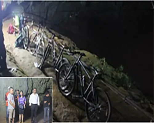
รถจักรยาน 11 คันถูกจอดอยู่ปากทางเข้าถ้ำ เจ้าหน้าที่ของวนอุทยานฯ พยายามตามหาเจ้าของรถจักรยานแต่ก็หาไม่พบ การรายงานผู้บังคับบัญชาและผู้ว่าราชการจังหวัดเชียงรายจึงเป็นจุดเริ่มต้นของการระดมเจ้าหน้าที่และผู้เชี่ยวชาญการสำรวจเข้ามาร่วมค้นหาเพิ่มขึ้น (ที่มา : ภาพต้นแบบจาก www.komchadluek.net)
11 bicycles were parked at the entrance to the cave. Park officials Tried to find the owner of the bicycle, but could not find The report of the supervisor and the governor of Chiang Rai is the beginning of the mobilization of staff and survey experts.
วันที่ 24 มิถุนายน 2561 :
June 24, 2018: