
หลากหลายความเห็นจากนักภูมิศาสตร์และการเตรียมพร้อมเพื่อเข้าพื้นที่ A variety of opinions from geographers and preparation to enter the area
วันที่ 24 มิถุนายน 2561 :
25 June 24, 2018:
เช้าตรู่ วันที่ 25 มิถุนายน 2561 ทีมข่าวหลายสำนักรายงานตรงกันว่าหน่วยชีล 17 นายได้เดินทางมาถึงถ้ำหลวงฯ และเริ่มต้นสำรวจในโพรงถ้ำพร้อมขุดเจาะทรายที่อุดทางเดินไปยังโถงกลาง ในขณะเดียวกันที่เจ้าหน้าที่ได้ข้อมูลจากชาวบ้านว่าบริเวณเหนือถ้ำหลวง-ขุนน้ำนางนอนมีโพรงที่สามารถทะลุถึงถ้ำได้ เจ้าหน้าที่จึงใช้เฮลิคอปเตอร์บินสำรวจบริเวณเหนือถ้ำค้นหาโพรง ซึ่งตามข่าวกล่าวว่าโพรงห่างจากโถงแรก 800 เมตร เจ้าหน้าที่ได้โยนอาหารและขนมพร้อมกระดาษที่มีข้อความให้หยุดรอหน่วยชีลที่กำลังตามหา พร้อมกันนี้ผู้ว่าราชการจังหวัดเชียงรายซึ่งเป็นผู้บัญชาการการค้นหาในพื้นที่ได้สั่งการให้เร่งสูบน้ำจากปากถ้ำ เดินสายไฟต่อหลอดไฟเข้าไปในถ้ำพร้อมวางแผนเพิ่มจำนวนเจ้าหน้าที่ดำน้ำ
Early in the morning on June 25, 2018, many news agencies reported that 17 SEAL units had arrived at the Royal Cave. And began to explore the cave cavities with sand drilling that blocked the walkway to the central hall at the same time, officials have received information from villagers that the area above the Tham Luang–Khun Nam Nang Non has a burrow that can penetrate the cave. Officials therefore use helicopters to explore the area above the cave and search for burrows. According to the news, the burrow was 800 meters away from the first hall. Officials threw food and snacks with paper with messages to stop waiting for SEAL units that was looking for. Simultaneously, the governor Chiang Rai, the search commander in the area, ordered the pumping of water from the mouth of the cave. Wiring light bulbs in the cave with plans to increase the number of diving officers.
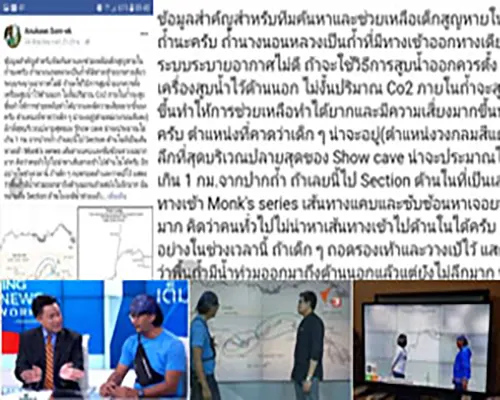
หลังจากข่าวการค้นหาเด็ก ๆ ที่หายเข้าไปในถ้ำหลวงฯได้แพร่กระจายและเริ่มได้รับความสนใจอย่างมาก อนุกูล สอนเอก นักภูมิศาสตร์ที่เคยสำรวจถ้ำหลวงได้โพสต์ในเฟซบุ๊ก Anukoon Sorn-ek ว่า “ข้อมูลสำคัญสำหรับทีมค้นหาและช่วยเหลือเด็กสูญหายในถ้ำนะครับ ถ้ำนางนอนหลวงเป็นถ้ำที่มีทางเข้าออกทางเดียว ระบบระบายอากาศไม่ดี ถ้าจะใช้วิธีการสูบน้ำออกควรตั้งเครื่องสูบน้ำไว้ด้านนอก ไม่งั้นปริมาณ Co2 ภายในถ้ำจะสูงขึ้นทำให้การช่วยเหลือทำได้ยากและมีความเสี่ยงมากขึ้นนะครับ ตำแหน่งที่คาดว่าเด็ก ๆ น่าจะอยู่ (ตำแหน่งวงกลมสีแดง) ลึกที่สุดบริเวณปลายสุดของ Show cave น่าจะประมาณไม่เกิน 1 กม.จากปากถ้ำ ถ้าเลยนี้ไป Section ด้านในที่เป็นเส้นทางเข้า Monk's series เส้นทางแคบและซับซ้อนหาเจอยากมาก คิดว่าคนทั่วไปไม่น่าหาเส้นทางเข้าไปด้านในได้ครับ อีกอย่างในช่วงเวลานี้ ถ้าเด็ก ๆ ถอดรองเท้าและวางเป้ไว้ แสดงว่าพื้นถ้ำมีน้ำท่วมออกมาถึงด้านนอกแล้วแต่ยังไม่ลึกมาก นั่นหมายถึง Section ด้านในจะมีน้ำท่วมแล้ว มีโคลนมากเขาคงไม่เข้าไปลึกมากครับ อาจจะมีปัญหาเรื่องแสงสว่าง ไฟฉายดับ หรือไฟฉายมีน้อยเลยหาทางออกจากถ้ำไม่ได้และระดับน้ำขึ้นซะก่อน ส่วนอันตรายที่สุดสำหรับทีมดำน้ำที่จะดำเข้าไปเป็น Section แรกที่ผมวงสีน้ำเงินเอาไว้ เนื่องจากเส้นทางเข้าแคบต้องมุดเข้าไปและน้ำจะอัดผ่านช่องนี้ออกมา อันตรายสำหรับทีมที่ดำน้ำขาออกแต่ถ้าผ่านจุดนี้ไปได้แล้วเส้นทางด้านในจะกว้างขึ้นสามารถเดินได้ครับ ข้อมูลเผื่อทีมช่วยเหลือจะนำไปใช้ในการวางแผนได้นะครับ สำหรับวิธีการช่วยเหลือ ต้องทำให้พื้นที่น้ำที่ท่วมเพดานถ้ำลดลงก่อน ด้วยลักษณะของถ้ำนางนอนหลวงลำธารที่เกิดขึ้นในถ้ำไม่ได้เกิดจากการไหลมาจากด้านนอก แต่เกิดจากฝนตกบนต้นน้ำและไหลซึมตามรอยแตกเข้ามา เวลาน้ำในถ้ำเริ่มขึ้นจะลงค่อนข้างยาก วิธีดีที่สุดจะต้องสูบน้ำออกให้มากกว่าปริมาณน้ำเข้า เราต้องคำนวณปริมาณน้ำที่ไหลในลำธารในถ้ำว่ามีปริมาณกี่ ลบม.ต่อวินาที และระดมเครื่องสูบน้ำให้ปริมาณ น้ำสูบออกมากกว่าปริมาณน้ำธรรมชาติ พื้นที่ส่วนเพดานถ้ำที่จมอยู่ถึงจะลด แต่ต้องไม่มีปริมาณฝนตกบนภูเขามาเพิ่มปริมาณน้ำในถ้ำอีก ดังนั้นต้องรีบสูบน้ำออกในระดับที่ปลอดภัยต่อผู้ช่วยเหลือ อย่าสูบน้ำออกโดยไม่มีหลักการครับ เวลาแต่ละนาทีที่ผ่านไปมันกลายเป็นเวลาที่สูญเปล่า ตอนนี้ประมาณ 36 ชม.หลังคนเข้าไปติดค้างอยู่ด้านใน เขายังรอดชีวิตและรอการช่วยเหลืออยู่ครับ” หลังการโพสต์ข้อความและแผนผังถ้ำหลวงของอนุกูลฯ สื่อมวลชนหลายสำนักโดยเฉพาะสื่อโทรทัศน์เริ่มให้ความสนใจเข้ามาสัมภาษณ์และสอบถาม แนวคิด วิธีการค้นหาและช่วยเหลือเด็ก ๆ ทั้ง 13 คนที่ติดอยู่ในถ้ำหลวงฯ
After the news of the search, the missing children in the royal cave spread and began to receive a lot of attention. Substrate, a geographer who had explored the Royal Cave, posted on Facebook Anukoon Sorn-ek that “Important information for the search and rescue team for missing children in the cave Nang N Luang Cave is a cave with one-way entrance. Poor ventilation system If using the pumping method, the pump should be set outside. Otherwise, the amount of CO2 inside the cave will be higher, making the help more difficult and riskier. The position that children expect is Probably the deepest (red circle position) at the end of the Show cave is probably not more than 1 km. From the mouth of the cave. If so, go to the inner section, which is the entrance to the Monk's series. The path is narrow and complex, very difficult. Think that people in general are unlikely to find a way to get inside. Another thing during this time, if children take off their shoes and put on a backpack, shows the cave floor is flooded to the outside but not very deep. That means the section inside is already flooded. There is a lot of mud. He probably won't go very deep. There may be a problem with lighting, a power outage, or a flashlight, so it can't find a way out of the cave and the water level the most dangerous part for the diving team to dive into is the first section that the blue band has put on. Since the narrow entrance has to be ducked in the water will compress through this hole. Dangerous for the team that dives out, but if this point has passed, the inner path will be wider, and able to walk. For the help team to be able to use in planning help methods Must reduce the water area that flooded the ceiling of the cave first with the nature of the cave, the sun's rays formed in the cave were not caused by the flow coming from the outside. But caused by rain on the upstream and seep along the cracks Entering the time when the water in the cave begins to rise is quite difficult. The best way is to pump out more than the amount of water in. We must calculate how much water flows in the streams in the cave. Per second mobilize the pump to give the amount of water pumping out more than the amount of natural water Sunken cave ceiling areas will reduce but there is no more rainfall on the mountain, increasing the amount of water in the cave Therefore have to hurry to pump out the water to a safe level for the helper. Do not pump water out without principles. Each minute that passes, becomes a wasted time. Now, about 36 hours. After the person is stuck inside, He is still alive and waiting for help.”
After posting messages and the royal cave map of the sub-section Many media, especially television, began to pay attention to interviews and inquire about how to find and help all 13 children who were addicted. In the royal cave
หลังจากนักภูมิศาสตร์ที่เคยสำรวจถ้ำหลวงฯ ได้โพสต์ข้อมูลและคำแนะนำสำหรับค้นหาและช่วยเหลือเด็กๆ ทำให้สื่อมวลชนจำนวนมากให้ความสนใจและขอเชิญสัมภาษณ์ผ่านรายการต่าง ๆ
After the geographers who had explored the Royal Cave Have posted information and advice for finding and helping children Causing many media to pay attention and invite interviews through various programs
วันที่ 26 มิถุนายน 2561:
26 June 24, 2018:
วันที่ 26 มิถุนายน 2561 ทีมกู้ภัยยังคงทำการค้นหาเด็ก ๆ ที่หายเข้าไปในถ้ำ แต่สิ่งที่เกิดขึ้นอย่างต่อเนื่องคือฝนตกและน้ำไหลเข้าในถ้ำตลอดเวลาจนระดับน้ำสูงขึ้นถึงผนังถ้ำด้านใน อย่างไรก็ตามหน่วยชีลซึ่งมีความชำนาญในการดำน้ำยังคงสำรวจถ้ำหลวงไปจนถึงโถง 4 แต่เนื่องด้วยน้ำเชี่ยวขุ่นและทางแคบหน่วยชีลจึงต้องถอนกำลังออกมาภายนอกก่อน
จากข้อมูลอุปสรรคในการค้นหาเด็ก ๆ ที่มีอยู่มากมายทำให้หลายหน่วยงานได้ส่งเจ้าหน้าที่และเครื่องมือต่าง ๆ มาช่วยเหลือในการค้นหาเพิ่มเติมขึ้นเรื่อย ๆ เช่น ศูนย์วิจัยเฉพาะทางวิศวกรรมอวกาศและทะเล มหาวิทยาลัยพระจอมเกล้าพระนครเหนือได้นำหุ่นยนต์ดำน้ำและโดรนติดกล้องตรวจจับความร้อนมาช่วยบินสำรวจค้นหา กรมชลประทานส่งเครื่องจักรกลมาช่วยสูบน้ำ เป็นต้น
On June 26, 2018, the rescue team continued to search for missing children in the cave. But what is happening is that it rains and water flows into the cave all the time until the water level rises to the inner cave wall. However, the Sheel unit, which is skilled in diving, is still being explored. The highway to Hall 4, but due to the turbulent water and the narrow path, the SEAL units had to withdraw from the outside first.
Due to the many obstacles to finding children, many agencies have sent staff and tools to help with more and more searches, such as specialized research centers in space and sea engineering. King Mongkut's University of Technology North Bangkok has brought diving robots and drones to heat detectors. Come to help fly to search Irrigation Department sends machinery to help pump water etc.
เครื่องมือและเทคโนโลยีต่าง ๆ ถูกนำมาใช้ในภารกิจนี้ เช่นเดียวกับหุ่นยนต์ดำน้ำและโดรนติดกล้องตรวจจับความร้อนก็ถูกนำมาช่วยสำรวจเพื่อค้นหาเด็ก ๆ (ที่มา: ภาพต้นแบบบางส่วนจาก www.prachachat.net)
Tools and technologies are used in this mission. Like diving robots and drones, heat detectors are also used to explore to find children.
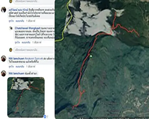
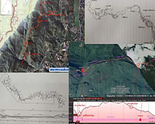
ในขณะที่อนุกูลฯ นักภูมิศาสตร์ได้กล่าวถึงเด็กทั้ง 13 ชีวิตว่าน่าจะติดอยู่ที่โถงสุดท้าย หากเจอแล้วก็จะช่วยนำออกมายาก พร้อมกันนี้ อนุกูลฯ ได้นำแผนที่โครงข่ายถ้ำของ Mr. Martin Ellis มาซ้อนทับกับแผนที่ภูมิประเทศมาตราส่วน 1 : 50,000 ของกรมแผนที่ทหาร และโพสต์ในเฟซบุ๊ก Geo CMU Alumni (เฟสบุ๊กศิษย์เก่าภูมิศาสตร์ มช.) ขอให้นักภูมิศาสตร์ช่วยสร้างแผนที่บน DEM เพื่อหาเส้นทางเข้าในถ้ำบริเวณทิศใต้ ซึ่งต่อมานักภูมิศาสตร์จำนวนมากได้นำข้อมูลมาสร้างเป็นแผนที่ถ้ำและบริเวณโดยรอบถ้ำหลวงขุนน้ำ-นางนอนทั้งในรูปแผนที่ 2 มิติ แผนที่ 3 มิติ แผนที่ผสมผสานซ้อนทับกับภาพถ่ายจากดาวเทียม ตลอดจนสร้างแผนที่ภาพหน้าตัดของพื้นที่ โดยส่งข้อมูลและคำแนะนำจำนวนมากกลับคืนไปให้ อนุกูลฯ เพราะหวังว่าข้อมูลจะถูกส่งเผยแพร่ผ่านสื่อ Social ออกไปยังพื้นที่ให้หน่วยที่กำลังค้นหาเด็ก ๆ ต่อไป
While the particle the geographer mentioned the 13 children that they should be trapped in the last hall. If found, it will be difficult to bring out at the same time. Martin Ellis overlaps with the Department of Military Map's 1: 50,000 scale topographic map. And posted on Facebook Geo CMU Alumni, ask geographers to help create a map on DEM to find directions to enter the cave in the south. Many geographers later created the information as a cave map and the surrounding area of the Tham Luang–Khun Nam Nang Non in both 2D maps and 3D maps, blends overlapping with photos from Satellites as well as creating cross-sectional maps of the area By sending a lot of information and advice back to the sub-section, hoping that the information will be distributed through Social Media to the area for the unit that is currently searching for children
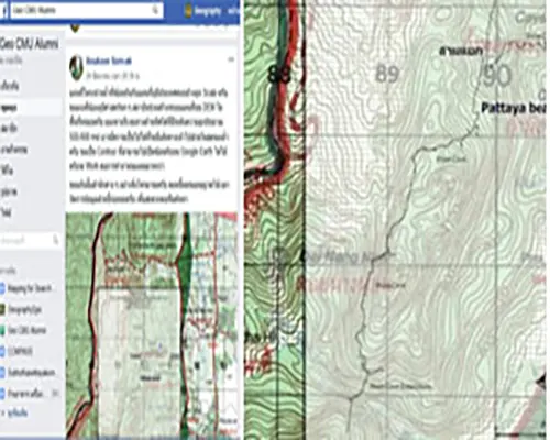
อนุกูลฯ นักภูมิศาสตร์นำแผนที่โครงข่ายถ้ำของ Mr. Martin Ellis ซ้อนทับกับแผนที่ภูมิประเทศ มาตราส่วน 1 : 50000 และขอให้นักภูมิศาสตร์ช่วยสร้างแผนที่บน DEM เพื่อหาเส้นทางเข้าในส่วนในสุดของถ้ำบริเวณด้านทิศใต้ที่สูงประมาณ 500-600 เมตรเหนือระดับน้ำทะเลปานกลาง (ที่มา : เฟซบุ๊ก Geo CMU Alumni)
The geographer (Anukoon Sorn-ek) led the cave network map of Mr. Martin Ellis overlaps with the topographic scale map 1: 50000 and asked geographers to help create a map on DEM to find the entrance to the cave at the southern end of the 500-600 meters above sea level.
นักภูมิศาสตร์จำนวนมากนำข้อมูลแผนที่โครงข่ายถ้ำที่ซ้อนทับกับแผนที่ภูมิประเทศ มาผสมผสานกับข้อมูลอื่น ๆ ที่มี แล้วสร้างเป็นแผนที่รูปแบบต่าง ๆ ส่งกลับคืนไปที่เฟซบุ๊ก Geo CMU Alumni
Many geographers bring information on cave network maps that overlap with topographic maps. Combined with other information available and then created as a map of various forms. Return to Facebook Geo CMU Alumni
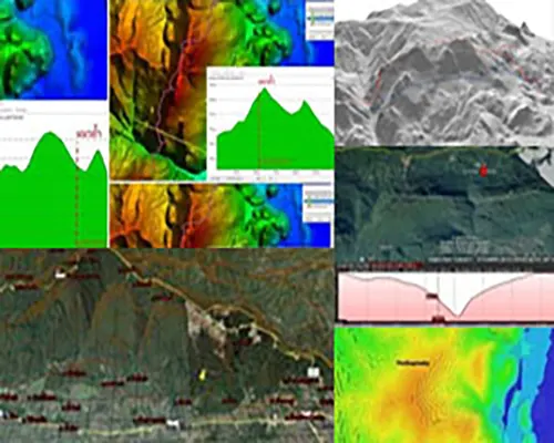
นักภูมิศาสตร์นำแผนที่ภูมิประเทศ และภาพถ่ายจากดาวเทียมบริเวณขุนน้ำนางนอนที่เป็นภาพ 2 มิติ ผลิตเป็นแผนที่ภูมิประเทศ 3 มิติโดยขบวนการ Interpolation ทำให้สามารถเห็นลักษณะของพื้นที่ได้ชัดเจนขึ้น (ที่มา: ภาพจากเฟซบุ๊ก Geo CMU Alumni)
The geographer leads the topographic map. Satellite imagery around the Tham Luang–Khun Nam Nang Non area, which is a 2D image produced as a 3D topographic map by the movement Interpolation Makes it possible to see the characteristics of the area more clearly.
นักภูมิศาสตร์นำภาพภูมิประเทศที่เป็นภาพ 3 มิติ มาซ้อนทับกับภาพถ่ายจากดาวเทียมจาก Google Earth ทำให้เห็นลักษณะภูมิประเทศที่เป็นธรรมชาติเหมือนพื้นที่จริง และทำการส่งเผยแพร่ผ่านเฟซบุ๊ก Geo CMU Alumni
The geographer overlaps the 3D imagery with satellite imagery from Google Earth, giving it a natural terrain like real space. And deliver via the Facebook: Geo CMU Alumni
แผนที่โครงข่ายถ้ำหลวงฯ ถูกนำมาซ้อนทับกับภาพถ่ายจากดาวเทียมในรูป 3 มิติ ทำให้เห็นลักษณะแนวถ้ำหลวงฯ ที่อยู่ภายใต้ดอยนางนอน
Map of the Royal Cave Network Was overlapped with satellite imagery in 3D, giving the view of the Tham Luang–Khun Nam Nang Non, Which is under Doi Nang Non.
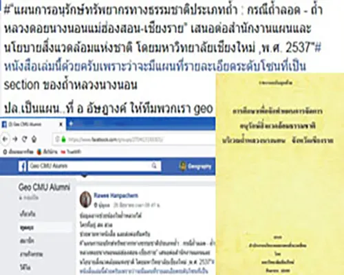
นอกจากข้อมูลที่ได้จากนักภูมิศาสตร์ที่เคยสำรวจถ้ำหลวงแล้ว นักภูมิศาสตร์หลายคนพยายามค้นหาข้อมูลที่มหาวิทยาลัยเชียงใหม่เคยศึกษาจัดทำแผนการจัดการอนุรักษ์สิ่งแวดล้อมธรรมชาติบริเวณถ้ำหลวงนางนอน จังหวัดเชียงรายเสนอต่อสำนักงานนโยบายและแผนสิ่งแวดล้อม ซึ่งมีรายงานฉบับนี้มีรายละเอียดอื่น ๆ ที่เคยทำการสำรวจถ้ำหลวงฯไว้ในปี พ.ศ. 2537
In addition to the information obtained from geographers who have explored the Tham Luang–Khun Nam Nang Non. Many geographers have tried to find information that Chiang Mai University has studied in creating a plan for managing the natural environment in Luang Nang Nong. Chiang Rai Province proposed to the Office of Environmental Policy and Planning. This report contains other details that have been surveyed in the Tham Luang–Khun Nam Nang Non. Retained in 1994
สำหรับผม(ใช้ชื่อบนเฟซบุ๊กว่า Geography2GIS) ได้ติดตามความเคลื่อนไหวของกลุ่มนักภูมิศาสตร์ ได้เสนอข้อคิดเห็น แนวคิดและข้อมูลผ่านเฟซบุ๊ก Geo CMU Alumni โดยแนะนำว่าควรคาดการณ์เหตุการณ์นี้จากความคิดของเด็ก เพื่อเดาว่าเด็กๆจะหาพื้นที่หลบพักที่ไหนเพื่อรอคนมาค้นหา และผมให้ข้อสังเกตเรื่องเส้นชั้นความสูงในแผนที่ภูมิประเทศ 1 : 50,000 เพื่อคาดการณ์ความหนาของภูเขาส่วนที่ครอบคลุมถ้ำหลวง ตลอดจนลักษณะความถี่ของเส้นชั้นความสูงว่าหากเป็นบริเวณที่เส้นชั้นความสูงถี่มาก ๆ แสดงว่าอาจจะเป็นรอยแตกหรือแนวของหินที่เลื่อน ซึ่งอาจจะมีโพรงรอดลงไปในถ้ำได้บ้าง (ภายหลังหลักการทางภูมิศาสตร์คือ “รอยแตกหรือแนวของหินที่เลื่อนอาจจะมีโพรงรอดลงไปในถ้ำ” ก็มีผู้เสนอแนวคิดนี้ไปประกอบการค้นหาตำแหน่งโพรงเข้าสู่ถ้ำหลวงฯ) และอาจจะประเมินความหนาของภูเขาซึ่งเป็นความลึกของโพรง พร้อมให้ข้อสังเกตว่าข้อมูลแผนที่ 1 : 50,000 ซ้อนทับกับแผนที่แนวถ้ำ เป็นข้อมูลค่อนข้างหยาบมีความคลาดเคลื่อนสูง (1mm = 50 m) แต่ก็ต้องทำทุกวิธีเพื่อหาทางช่วยค้นหาเด็ก ๆ
I (the name on Facebook is Geography2GIS) have followed the movement of geographers. Offer ideas Concepts and information through Facebook Geo CMU Alumni, suggesting that this event should be predicted from children's thoughts. To guess where the children would find shelter to wait for people to search I observed the contour in the topographic map 1 : 50,000 to predict the thickness of the mountain covering the royal cave As well as the frequency characteristics of the contour, if it is an area where the contour is very short, it may be a crack or a line of sliding stones. Which may have some burrows to survive in the cave (After the principle Geographically, “cracks or sliding stones may have a burrow to survive in the cave. ” This concept was proposed for the search for cavities to enter the Royal Cave) and may assess the thickness. Of the mountains which are the depth of the cavity Ready to note that map data 1 : 50,000 overlay with the cave map It is quite rough information, with high tolerances (1mm = 50 m), but it must be done in every way to find a way to find children.
ในวันที่ อนุกูลฯ นักภูมิศาสตร์นำแผนที่โครงข่ายถ้ำของ Mr. Martin Ellis ซ้อนทับกับแผนที่ภูมิประเทศ มาตราส่วน 1 : 50000 และขอให้นักภูมิศาสตร์ช่วยสร้างแผนที่บน DEM เพื่อหาเส้นทางเข้าในถ้ำนั้น ผมคิดว่านอกจากการสร้างแผนที่บน DEM แล้ว แนวคิดผสมผสานด้านภูมิศาสตร์มนุษย์น่าจะมีประโยชน์จึงได้เสนอข้อคิดเห็น แนวคิดเชิงหลักการในค้นหาเด็กๆ ส่งผ่านไปยังเฟซบุ๊ก Geo CMU Alumni
the geographer brought the cave network map of Mr. Martin Ellis overlaps with the scaled topographic map 1 : 50000 and asked geographers to help create a map on DEM to find directions in that cave. I think that the concept of human geography should be useful, so I have a comment. Principal concepts in finding children Passed to Facebook Geo CMU alumni.
วันที่ 27 มิถุนายน 2561 :
27 June 24, 2018:
วันที่ 27 มิถุนายน 2561 น้ำในถ้ำยังสูงขึ้น การติดตั้งไฟและลำเลียงเครื่องสูบน้ำขนาดใหญ่เข้ามาเพิ่มในพื้นที่เพื่อเร่งสูบน้ำยังคงทำอย่างต่อเนื่อง เริ่มมีแนวคิดการเข้าสู่ถ้ำด้านบน นักธรณีและผู้เชี่ยวชาญเรื่องถ้ำพยายามวิเคราะห์ความหนาของผนังถ้ำเพื่อประเมินการเจาะโพรงถ้ำ พร้อมกันนี้ชุดโรยตัวเริ่มเดินขึ้นดอยผาหมีสำรวจโพรงที่จะโรยตัวเข้าไปช่วยเด็ก ๆ
ในเวลาต่อมาเฟซบุ๊ก Thai navySEAL ได้รายงานว่าเครื่องสูบน้ำมีกำลังไม่เพียงพอที่จะทำให้น้ำลด ฝนยังตกต่อเนื่องจนน้ำท่วมถึงห้องโถง 3 ขณะที่ทีมสำรวจดอยผาหมีได้พบโพรงบนเขา แต่เมื่อลงไปสำรวจพบว่าโพรงนั้นตัน
ในตอนเย็นวันเดียวกันนี้ผู้ชำนาญการดำน้ำจากอังกฤษที่ไทยขอความช่วยเหลือจำนวน 3 คนได้เดินทางมาถึงสนามบินแม่ฟ้าหลวงและเดินทางถึงถ้ำหลวงฯในตอนค่ำวันเดียวกันนี้
ในขณะที่ตลอดวันนักภูมิศาสตร์ผลิตแผนที่จำนวนมาก พร้อมเริ่มระดมสมอง รวบรวมข้อมูลและวางแผนเข้าพื้นที่ โดยอนุกูลฯ ได้โพสต์ขอผู้เชี่ยวชาญแผนที่ภาคสนาม 5 คน ร่วมช่วยปฏิบัติภารกิจช่วยชีวิตเด็ก ๆ 13 ชีวิต แผนการจัดการอนุรักษ์สิ่งแวดล้อมธรรมชาตบริเวณถ้ำหลวงฯ ถูกนำเอาข้อมูลมาใช้งาน ข้อมูลเริ่มมีรายละเอียดและจำนวนมากขึ้น ทั้งแผนที่ถ้ำหลวงที่อธิบายความสูงต่ำ ขนาดความกว้าง-สูง-ต่ำของทางเดินภายในถ้ำ จุดที่วิเคราะห์ว่าปลอดภัย จุดที่เสี่ยง จุดที่คาดว่าเด็กหลบอยู่ โดยข้อมูลมากมายที่รวบรวมและสร้างขึ้นถูกส่งเผยแพร่ออกไปผ่าน Social media เพื่อเป็นเครื่องมือประกอบการวางแผนช่วยเหลือเด็ก
On June 27, 2018, the water in the cave was still higher. Electrical installation and conveying of large pumps added to the area to accelerate the pumping are still ongoing. Begin with the idea of entering the cave above. Geologists and cave experts try to analyze the thickness of the cave walls to assess. Penetrating the cave cavity at the same time, the sprinkling set began to walk up the Doi Pha-Mee survey team and explored the burrow to sprinkle in to help the children.
Later, Facebook Thai NavySEAL reported that the pump was not enough to reduce the water. The rain continued until the flood reached Hall 3, while the Doi Pha-Mee survey team found a hole in the mountain. But when going down to explore, found that the burrow.
On the same evening, 3 British diving specialists in Thailand asked for help arriving at Mae F Luang Airport and arriving at Luang Cave on the same evening.
While all day, geographers produce many maps. Ready to start brainstorming Gather information and plan into the area. The sub-section has posted 5 field map experts to help with the mission to save the lives of 13 children. The plan for managing the environment and the genitals of the Royal Cave area has been taken. Data comes to use. The data starts to be more detailed and larger. Both the royal cave map describes the low height and the width-high-low size of the cave walkway The point that is analyzed is safe. Risk points are the point where children are expected to be hiding With much information collected and created being sent out through Social media as a tool for planning children
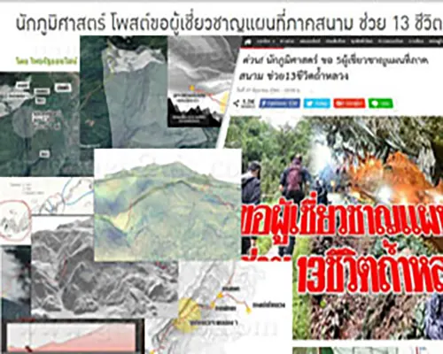
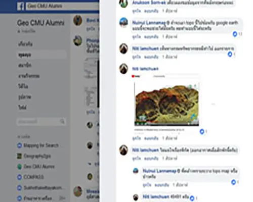
นักภูมิศาสตร์เริ่มรวบรวมข้อมูลและวางแผนเข้าพื้นที่ พร้อมกับโพสต์ขอผู้เชี่ยวชาญด้านแผนที่ภาคสนามจำนวน 5 คนเพื่อร่วมช่วยปฏิบัติภารกิจนี้ (ที่มา : ภาพจากเฟซบุ๊ก Geo CMU Alumni และจาก www.komchadluek.net)
Geographers began collecting data and planning for the area. Along with the post asking 5 field map experts to help with this mission.
นักภูมิศาสตร์เริ่มจัดเก็บและแรกเปลี่ยนข้อมูล ข้อมูลจากแผนการจัดการอนุรักษ์สิ่งแวดล้อมธรรมชาติบริเวณถ้ำหลวงนางนอน จังหวัดเชียงราย และข้อมูลอื่น ๆ ถูกนำมาเป็นข้อมูลสร้างแผนที่ใหม่ๆ ที่มีรายละเอียดมากขึ้น ชัดเจนขึ้น (ที่มา : ภาพจากเฟซบุ๊ก Geo CMU Alumni)
Geographer began to store and first change the data. Data from the Natural Environment Conservation Management Plan, the Tham Luang–Khun Nam Nang Non Chiang Rai Province, And other information is used as information to create new maps More detailed, clearer
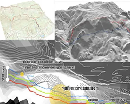
นักภูมิศาสตร์ผลิตแผนที่ใหม่ๆ ที่มีรายละเอียดมากขึ้น ชัดเจนขึ้น เช่น แผนที่โครงข่ายถ้ำหลวงฯ ซ้อนกับแผนที่ภูมิประเทศและ Hillshade เป็นภาพ 3 มิติ แสดงแนวถ้ำหลวงฯ ด้านบนและพื้นราบของภูเขา พร้อมคาดการณ์จุดที่เด็ก ๆ อาจจะพักอยู่ (ที่มา: ภาพจากเฟซบุ๊ก Geo CMU Alumni)
Geographers produce new maps. More detailed, clearer, such as the Royal Cave Network Map Stacked with topographic maps and Hillshade is a 3D image showing the royal cave. Top and flat ground of the mountains Ready to predict where children may stay.